
Navigation Solutions
Enterprise Scale Project and Fleet Management
Installing infrastructure represents the costliest aspect of commercial offshore developments.
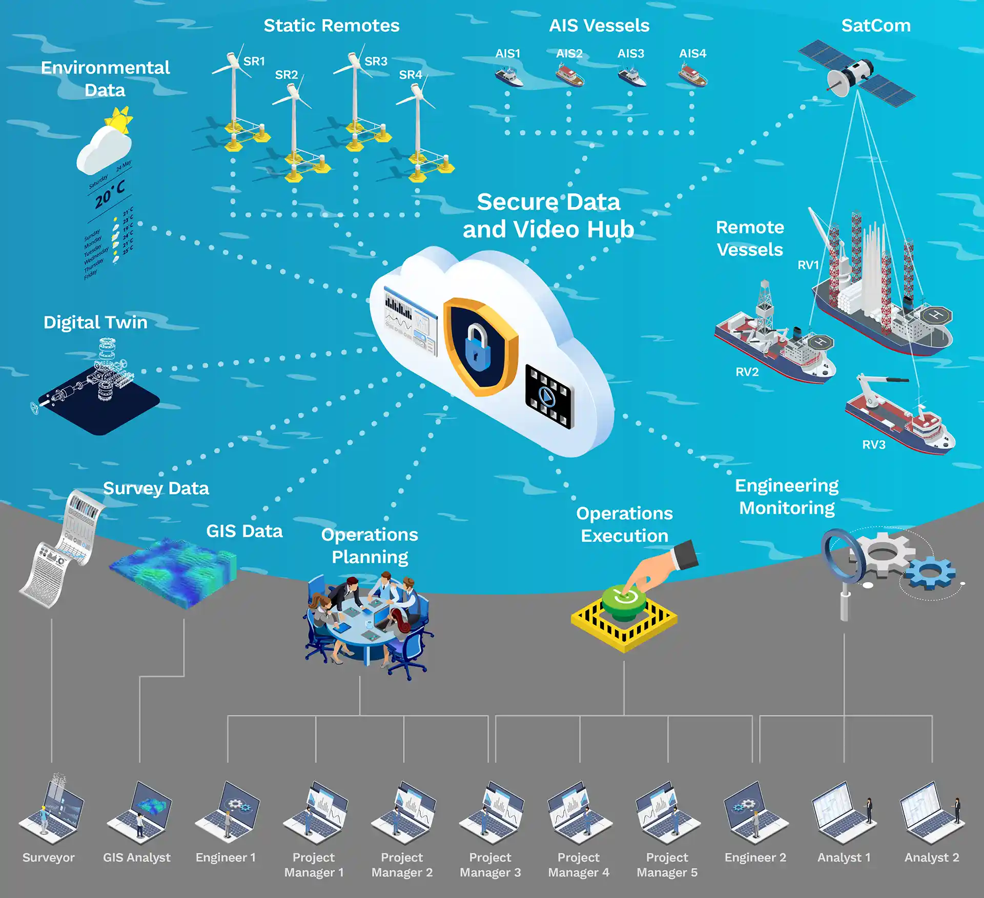
Our enterprise-scale command and control system enhance operational efficiency while significantly cutting costs. We have designed our technological components to work seamlessly together, offering unprecedented situational awareness to both offshore and onshore team members during infrastructure installation and maintenance operations.
Our remote technology enables a reduction in the number of personnel engaged in an operation, thereby lowering expenses. Our technology models projects, operations, and fleets of vessels, utilizing advanced spatial, video, voice, and engineering data storage and retrieval methods for planning and execution operations.
Features & Benefits

Defining a project
Defining a Project
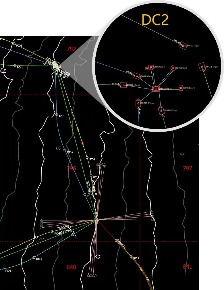
At the enterprise level, a project refers to a specific geographic area being developed for commercial purposes, such as an oil field or a wind farm. For example, in the oilfield sector, we represent a project using base maps and plans that are overlaid with infrastructure like pipelines, production units, risers, manifolds, and trees.
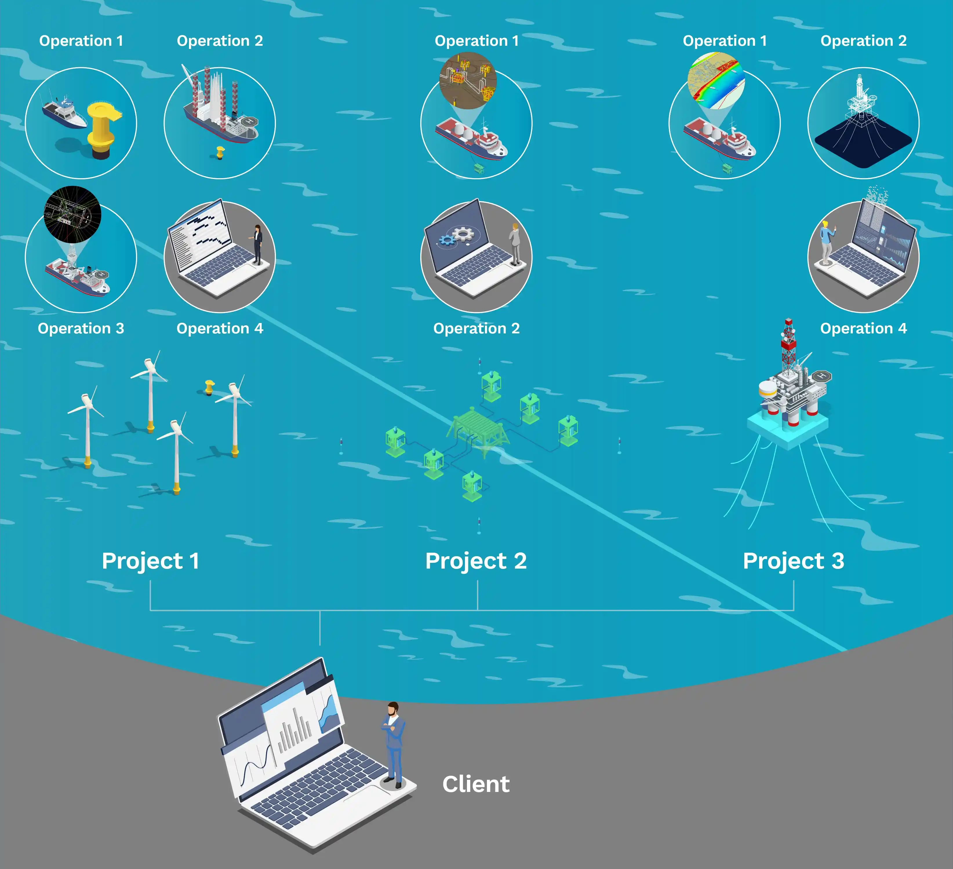
Defining an Operation
An operation is a task associated with developing a project's infrastructure or gathering related data. Operations include creating plans to achieve the goals and utilizing vessels to carry out those plans. For instance, in the wind farm sector, this could involve performing maintenance on a turbine or installing a power cable.
Defining a Fleet
A fleet is a collection of vessels that a company may control. Vessels may be assigned to an operation from a single fleet or multiple fleets. We have a library of vessels that include characteristics such as available ROVs, a physical outline, and an OrcaFlexTM model.
Setting Up the Project
In the early stages of a project, data are typically gathered to characterize the seabed and other features that influence its development. Our NavView software can plan for and collect data for this purpose. Our mission planning feature enables the efficient coverage of large areas by multiple AUVs or ASVs without interference.
Our onshore servers can store the resulting data products in a versioned manner, making them available throughout the development process. This approach avoids the costs associated with multiple transcriptions and ensures that the data is accessible to clients through our NavScape web application or to existing systems, such as corporate GIS.

Benefits
Accurate Simulations
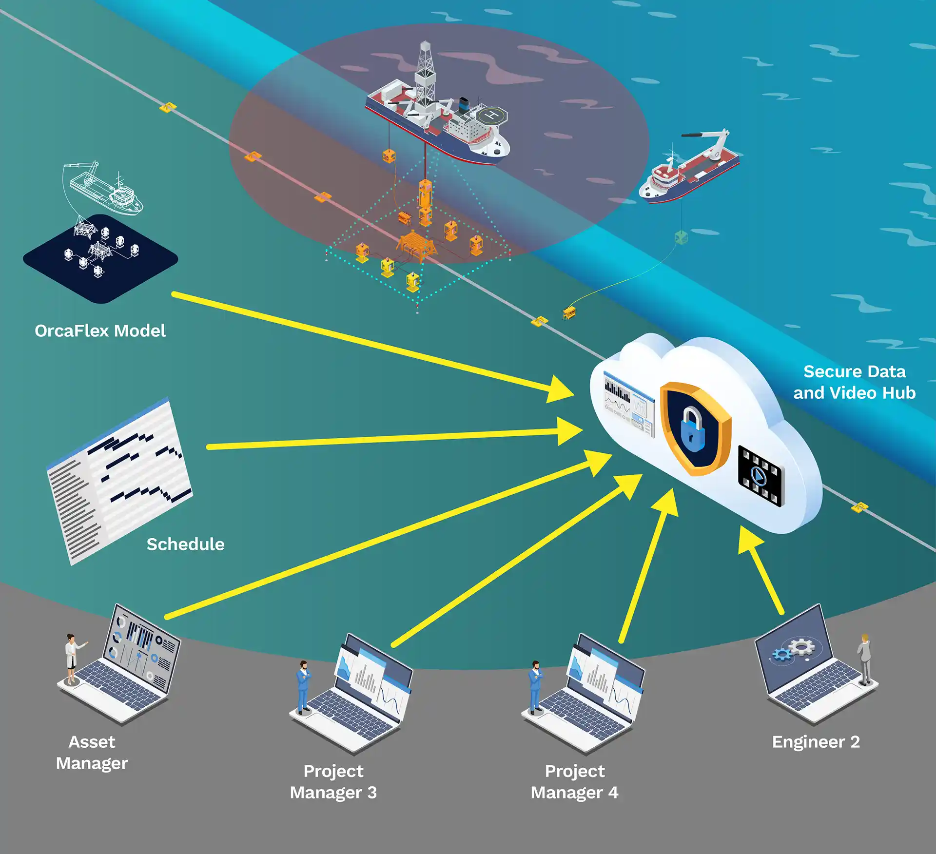
As development plans advance and operations are defined to construct the necessary infrastructure, we can offer simulations of operations using multiple vessels and OrcaFlexTM models produced by the engineering departments. Additionally, we can provide Simops planning to ensure there are no conflicts within or between operations, thereby reducing vessel time and cutting cost.
Operation Execution
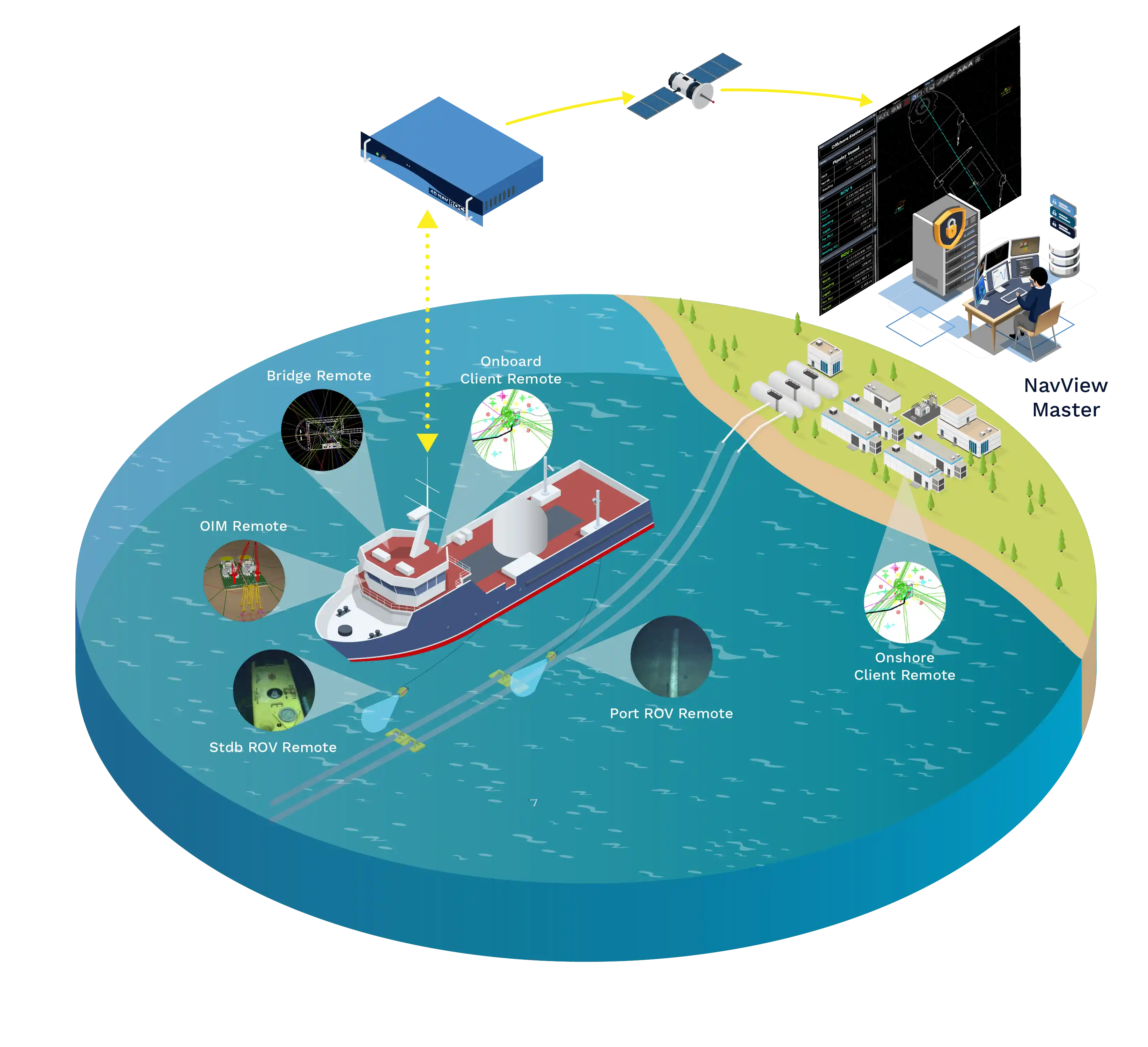
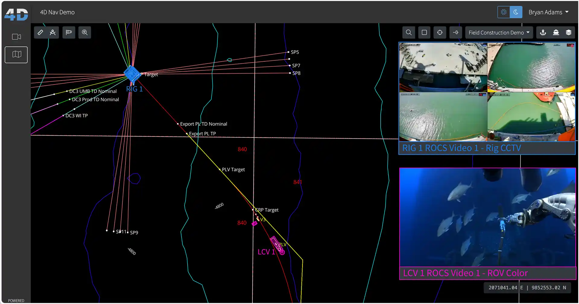
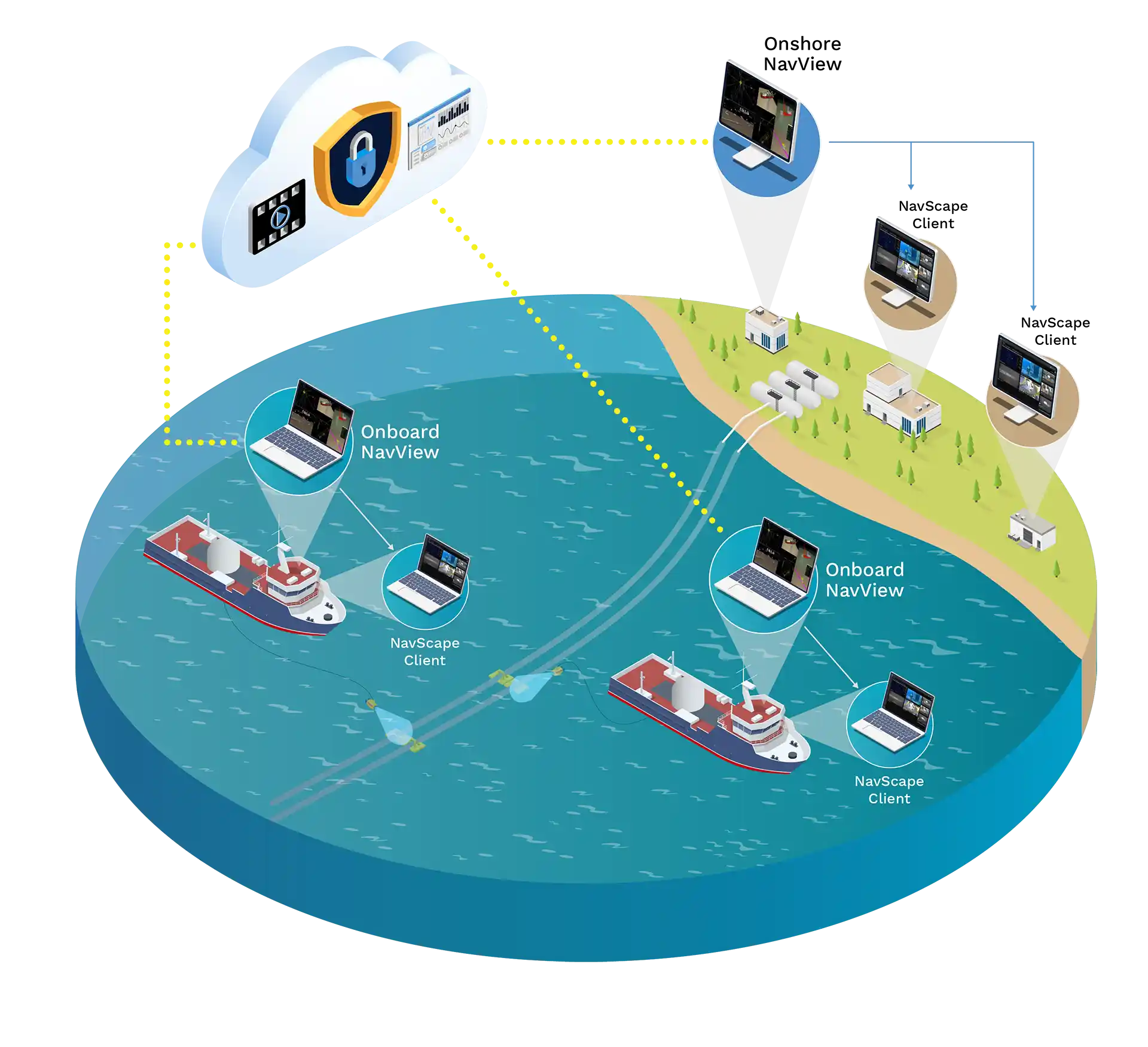
As operations proceed, our NavView system serves as the eyes of the operation. On a vessel, a NavView master system is operated by a surveyor or remotely from a synchronized station onshore. Multiple smart remote NavView stations are installed on the vessel to provide coordinated views of tasks, each configurable for specific functions such as a bridge station, an ROV pilot station, or an OIM station. Our Remote Operations Control System (ROCS) hardware platform establishes a secure connection from the vessel to our onshore servers via a satellite link or a local infrastructure-based link. This also allows the master NavView station to be controlled remotely from onshore.
The primary interface used by the stations on the vessel features an intricate and highly responsive map display, showing details of the vessel and ROVs over a plan of the area. These are supplemented by text displays indicating the required movements of vessels and ROVs.
Inclusive Access for All
Our web application, NavScape, provides access to all. NavScape makes the eyes and ears of offshore operations accessible onshore, enabling simultaneous coordination of actions among multiple vessels. The key feature that enables this is an extremely high-performance map that mirrors the one provided by NavView, along with other interfaces used in smart remote stations on the vessels. NavScape also enables monitoring of Simops plans to ensure compliance and displays other vessels in the area using AIS data to prevent operational interference.
Full Situational Awareness
NavScape provides views of video feeds from our ROCS units and grants access to the Clear-Com voice interface used on most ships, fully immersing onshore users with personnel onboard. Our remote NavView technology fully synchronizes offshore systems with onshore systems, allowing for complete remote control from onshore, which leads to significant cost savings. The remote technology supports monitoring multiple NavView systems from a single station, enabling one operator to service several vessels.
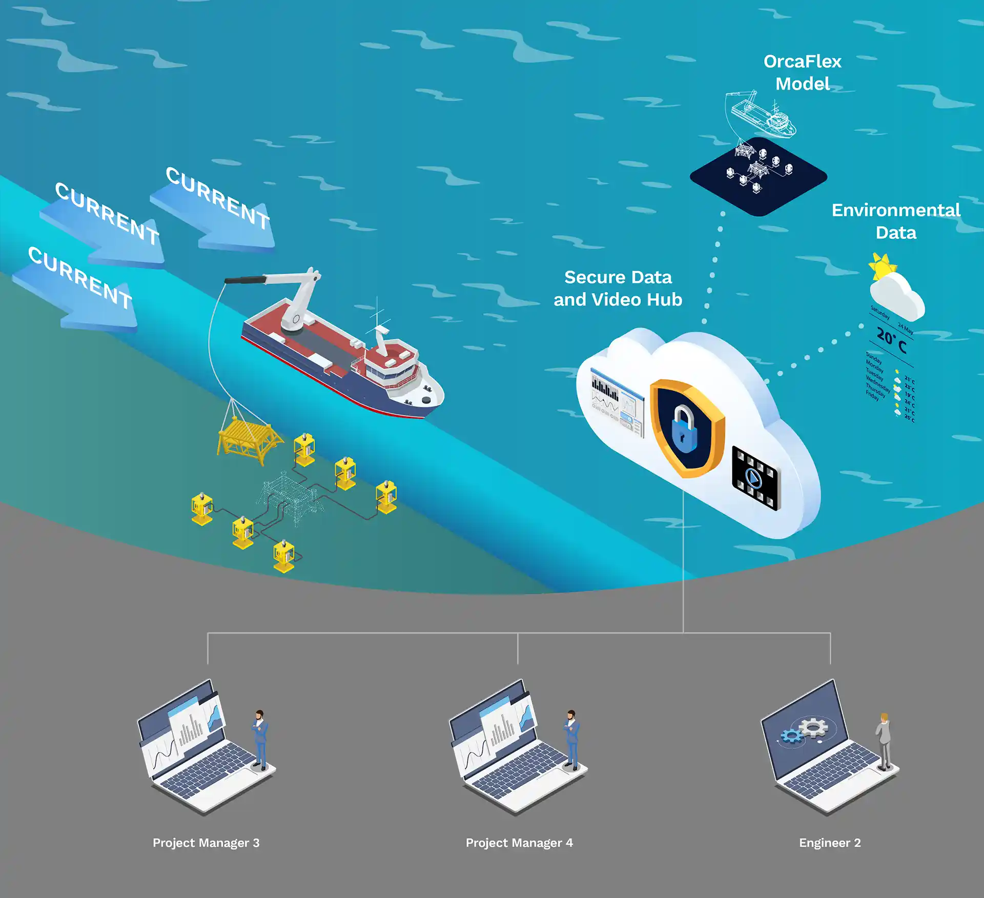
Modeling Operations in the Water Column
Most operations involve installing infrastructure from a vessel through the water column to the seabed and are affected by environmental conditions. Our detailed integration with OrcaFlexTM allows NavView to use models made during the planning phase to be used during operations to provide high-current mitigation and visualize complex subsea operations. This saves vessel time and ensures plans are not deviated from. NavView also provides integration with environmental data such as winds and currents to assist with short term planning. Since NavScape is connected to the NavView system, project personnel onshore have the ability to participate in operations by refactoring procedures to address unexpected environmental conditions.
Coordinate Systems That Make Sense
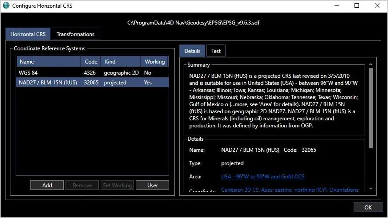
All projects communicate information on placing and maintaining infrastructure by using a specific coordinate system which falls under the term geodesy. Unlike GIS-based map displays, our technology utilizes the same geodesy employed for each project, ensuring that the coordinates used on the vessel can also be applied onshore. NavScape enables users to access multiple projects, allowing them to switch between them and engage in various operations.
A Holistic Approach to Operations Execution
NavScape unifies all project components into a single user interface, aimed at reducing project scheduling conflicts and vessel time, enhancing productivity, and offering an unmatched approach to situational awareness in projects. From the initial stages of planning to the final phases of execution and reporting, NavScape stands as the premier project management tool.
Ensure streamlined and safe offshore operations with Enterprise Scale Project and Fleet Management
For more information about our industry leading software, please reach out to schedule a demo.
BOOK A CALL